|
|
| |
Discover
South Ferriby - North Lincolnshire |
South
Ferriby
is one of five that lie on the road that
runs between the River Humber & Brigg.
The five villages, collectively known as
the "Low Villages" as they are
located along the foot of the North Lincolnshire
Wolds are Worlaby,
Bonby,
Saxby-all-Saints,
Horkstow
& South
Ferriby.
The Village has a number
of interesting buildings including Saint
Nicholas Church, the Reading Room , the
Old Post Office, Methodist Chapel &
the Primary School. You can also enjoy the
River Ancholme & River Humber as well
as taking in the spectacular view of
Reads Island from
the Wolds.
|
|
The
Reading Room |
|
|
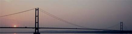
The
Location -
South
Ferriby is a village and parish in North
Lincolnshire situated where the Northern
end of the Lincolnshire Wolds meet the south
bank of the River Humber. South Ferriby
lies 9 miles west of Hull, 11 miles east
of Scunthorpe, 25 miles north-west of Grimsby
and 3 miles south-west of Barton on Humber.
|
|
| |
The
Place-name & its Origins |
South
Ferriby as the name suggests is
defined as 'The farmstead or village beside
the ferry'. South Ferriby has through the
ages been known as the following:- Ferriby,
Ferraby, Ferribi, Ferebi, Ferya By, Ferrebe,
North Ferebe, which is shown on an old map
dating from 1610 and
South Ferraby (in 1842). It is South in
raltionship to North Ferriby which is located
on the opposite bank of the River Humber.
The Doomsday
Book (1086)
referred to the village as "Ferebi".
Other
names - for the village include
Suth Feriby
The
name - can be translated to 'The
farmstead or village at the ferry'. It is
South in contrast to North Ferriby which
is located on the opposite bank of the River
Humber.
-by - farmstead,
village - (Old Norse - by)
Top |
|
The
History of South Ferriby can be
traced back to 800 to 900AD when it was
named Ferrebe which suggests it was named
by the Danes. Archeological finding including
many Roman coins and jewelry were found
in the nineteenth century.
During the reign of King Canute there was
a ferry crossing over the river Humber between
South Ferriby & North Ferriby . The
Doomsday Book records a church, mill and
two ferries which suggests that there was
a prosperous trading community.
In
the past, South Ferriby, despite its size
had many industries, including, ship building,
brick manufacture, cement manufacture, agriculture,
blacksmiths and mills which provided much
of the employment within the village.
A number of springs which are dotted around
the village enabled South Ferriby to be
one of the first in the country to have
its own piped water supply.
Top
|
|
| |
Population Through
The Years |
Year
- Population
|
Year
- Population |
1801-
280
1811 - 420
1821 - 453
1831 - 500
1841 - 542
1851 - 580
1861 - 573
1871 - 721
1881 - 733
1891 - 638 |
1901-
738
1911 - 725
1921 - 736
1931 - 701
1941 - N/A
1951 - 696
1961 - 663
1971 - 607
1981 - 619
1991 - 614 |
Top |
|
The
church of St Nicholas, which is but the
mutilated remnant of a much larger church,
is a singular structure, consisting of nave,
south transept, north porch and an embattled
tower, with pinnacles, at the south-east
angle, containing 3 bells: over the porch
is an ancient semicircular stone, on which
is a sculptured a figure of St Nicholas,
vested in alb and mitre, and holding a pastoral
staff in his left hand; and on either side
are symbolical figures of the sun and moon;
in 1869 the church was repewed and restored
at a cost of £350, and in 1889 was
again restored and a sacrarium built at
a cost of £1,092, by the Right Rev.
Bishop Tozer D.D. then rector:
....[entry
from Kelly's Trade Directory for 1900]
Top |
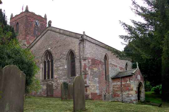
Saint
Nicholas Church |
|
|
|
| |
|
Hope
& Anchor
Sluice Road
South Ferriby,
North Lincolnshire,
DN18 6JQ
Tel: 01652 635242
Nelthorpe
Arms
School Lane
South Ferriby,
North Lincolnshire, DN18 6HW
Tel: 01652 635235
|
Map
| Microsite |
|
|
|